


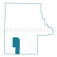
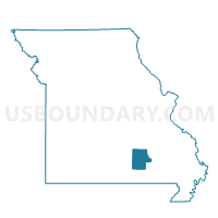
Birch Tree Voting District, Shannon County, Missouri
About
Outline

Summary
| Unique Area Identifier | 611384 |
| Name | Birch Tree Voting District |
| County | Shannon County |
| State | Missouri |
| Area (square miles) | 49.15 |
| Land Area (square miles) | 49.15 |
| Water Area (square miles) | 0.00 |
| % of Land Area | 99.99 |
| % of Water Area | 0.01 |
| Latitude of the Internal Point | 36.98041270 |
| Longtitude of the Internal Point | -91.49697520 |
Maps

Graphs
Select a template below for downloading or customizing gragh for Birch Tree Voting District, Shannon County, Missouri


Neighbors
Neighoring Voting District (by Name) Neighboring Voting District on the Map
- Bartlett Voting District, Shannon County, MO
- Delaware Voting District, Shannon County, MO
- Montier I & II Voting District, Shannon County, MO
- Moore & Blackpond Voting District, Oregon County, MO
- Spring Creek Voting District, Shannon County, MO
Top 10 Neighboring County Subdivision (by Population) Neighboring County Subdivision on the Map
- Birch Tree township, Shannon County, MO (1,273)
- Montier township, Shannon County, MO (693)
- Bartlett township, Shannon County, MO (443)
- Spring Creek township, Shannon County, MO (363)
- Black Pond township, Oregon County, MO (164)
- Delaware township, Shannon County, MO (91)
Top 10 Neighboring Place (by Population) Neighboring Place on the Map
Top 10 Neighboring Unified School District (by Population) Neighboring Unified School District on the Map
- Mountain View-Birch Tree R-III School District, MO (8,022)
- Alton R-IV School District, MO (4,750)
- Summersville R-II School District, MO (3,058)